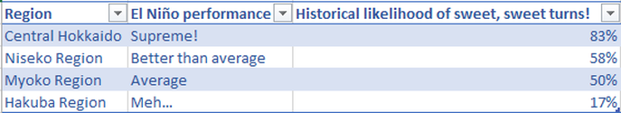
The effects of El Niño on the Niseko area
58% of the time, Niseko has out-performed it's
average snowfall during El Niño cycles
average snowfall during El Niño cycles
Conclusion:
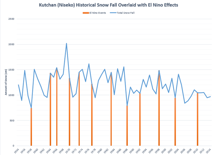
Between 1954 and 2014, JMA recorded an average annual snowfall in the Niseko region of 1,207cm. During the 12 El Niño cycles listed below, 5 years had snow fall below the average and 7 years had snow fall above the average, indicating that an El Niño cycle in Niseko is historically likely to produce above-average snow fall conditions.
Chart Analysis:
The blue line in the chart below denotes how much snow fall was recorded by the Japan Meteorological Agency (JMA) for the time span of 1953 to 2014 (years located on the X-axis). The intersecting orange bars indicate El Niño years recorded by JMA for Japan.
While some El Niño years such as 1958, 1992, 1988, and 2004 show a decline in snow fall during El Niño period, other years such as 1964, 1966, 1972, and 1998 show a peak of snow fall during the weather system. Still other years such as 1978 and 2010 indicate average snow fall during El Niño.
How does Niseko compare to other regions in Japan?
Some technical information:
The chart above shows historical snow fall data for the town of Kutchan, located 16 minutes from the Hirafu base of Niseko United. The elevation of Kutchan is just under 200m while the elevation of the Niseko resorts ranges from 320m to 1,200m; the difference in elevation means that Niseko will receive more snow, but that Kutchan is close enough to extrapolate general trends in the area.
The source of El Niño years can be found here, the source of historical snow fall data can be found here. The data provided by JMA is for Kutchan WMO Station ID:47433 Lat 42o54.0'N Lon 140o45.4'E