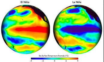
What effect will La Niña have on the ski season in Japan?
You've asked the magic question everyone's trying to find out. When the Japan Meteorological Agency (JMA) declares a La Niña cycle "likely" for a winter season, what will this mean for your Japan ski trip? This is a common question we've gotten so we did a bit of research and this page is the result.
 La Niña is characterized by unusually cold ocean temperatures in the Equatorial Pacific
To get an idea of what this means for Japan Powder, we've taken a look at over 50 years of data provided by the JMA and cross-referenced it by La Niña cycles. The results are variable and sometimes surprising, causing laughter, cheering and sometimes tears.
<
>
With a winning 62% chance of an above-average season, Central Hokkaido wins the La Niña wars! With a 62% chance of outperforming an average year, the Central Hokkaio region (which encompasses such areas as Kamui Ski Links and Furano) comes in first place for the likelihood of an above-average snow dump this winter! Hooray for them! The conclusion: Between 1954 and 2014, JMA recorded an average annual snowfall in the Asahikawa region of 617cm. During the 13 La Niña cycles listed below, 5 years had snowfall below the average and 8 years had snowfall above the average, indicating that an La Niña cycle in the Asahikawa region is historically likely to produce above-average snowfall conditions! See the full analysis here. 53% of the time, Niseko has out-performed it's average snowfall during La Niña cycles Conclusion: During the 13 La Niña cycles listed below, 6 years had snow fall below the average and 7 years had snow fall above the average, suggesting that La Niña cycle in Niseko is historically likely to produce barely-above-average snowfall conditions. BUT don't start getting excited just yet; the 53% average is mostly being carried by numbers before 1989 (notice how the orange lines go up higher on the left side of the chart than the right). From 1989 and beyond, La Niña is mostly associated with below-average snowfall, which could indicate a change in long-term trends in the region. See the full analysis and charts here. Historically, La Niña brings a 46% chance of an above-average snow year in the Niigata region Conclusion: During the 13 La Niña cycles listed below, 7 years had snowfall below the average and 6 years had snow fall above the average, indicating that a La Niña cycle in the Niigata region historically brings a higher likelihood of slightly-blow-average snowfall. While the average may slightly favor an below-average dump, the chart suggests that La Niña in this region is historically a gamble with huge rewards when its on (see 2011), and big disappointments when its not (see 2006). The data point to the effects of La Niña in the Myoko/Niigata region to be big. Unfortunately for us, history doesn't give us any strong indicator of which way that big influence is going to go. This year looks like a gamble, but if it wins it looks like it'll win really big. For years with big wins (high snowfall), see 1985, 2000, and 2011 on the chart below. For years with big losses (low snowfall) see 1965, 1972 and 2006. See the full analysis and chart here. During La Niña cycles, Nagano outperforms the average snowfall only 39% of the time Conclusion: Between 1954 and 2014, JMA recorded an average annual snowfall in Nagano City (the closest JMA weather station to Hakuba) of 173cm. During the 13 La Niña cycles listed below, 8 years had snowfall below the average and 5 years had snowfall above the average, suggesting that a La Niña cycle in the Nagano region is historically likely to produce below-average snowfall conditions. While the odds of a good snow year in Nagano aren't great, its not as bad as the 17% chance forecasted for the 2015/16 El Niño season which ended up being pretty accurate (you can view that forecast here). See the chart and full analysis here. |
A few things to remember when looking at this data:
- All data is provided by the Japan Meteorological Agency (JMA) and spans from 1953 to 2014
- The snow fall recorded by JMA is not located at the ski resorts themselves, but at the nearest weather station which may be located at lower, less prone-to-precipitation areas. The exact location of the weather station is noted on each chart. Despite not being located at the exact ski resort, the nearby weather stations should give a good indication of general weather conditions in the nearby area.
- The snow fall data doesn't reflect cumulative snowfall data, but just the amount that fell from the sky (doesn't take into account loading/scouring, melting, settling, drifting, etc).


