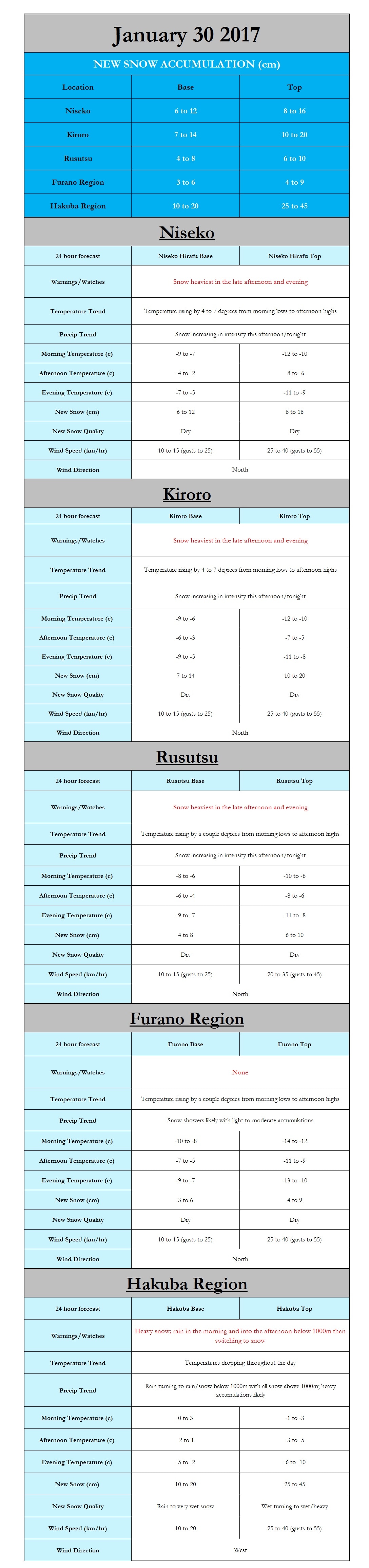
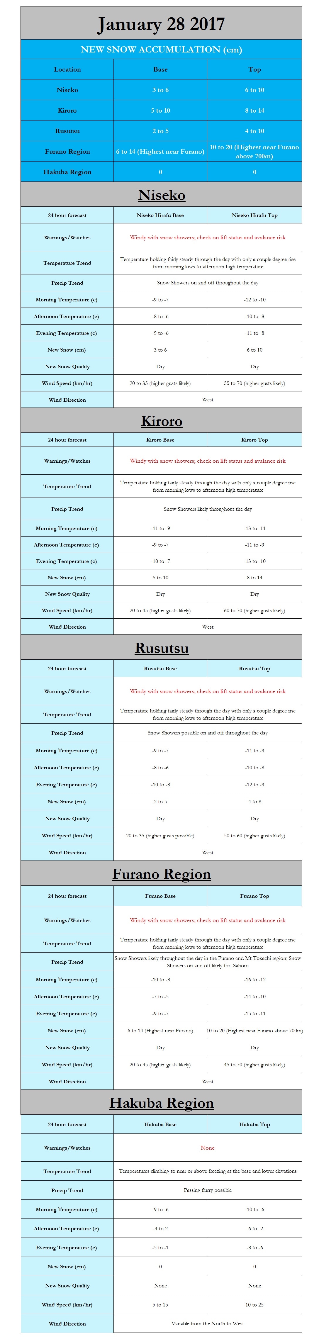
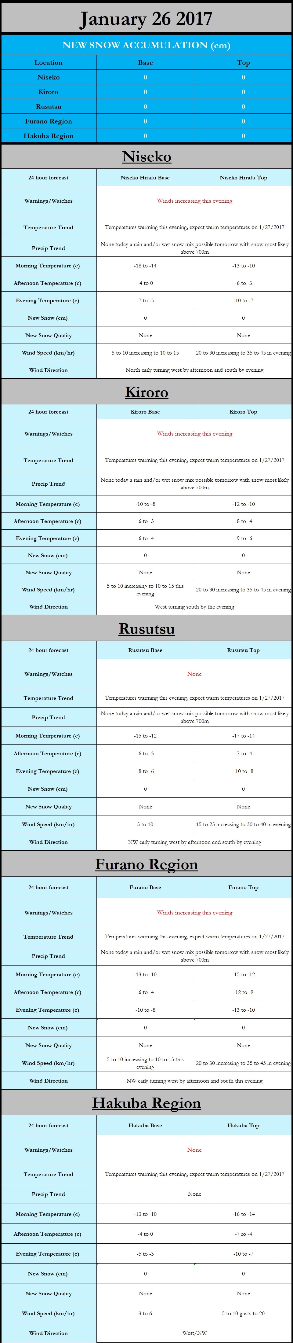
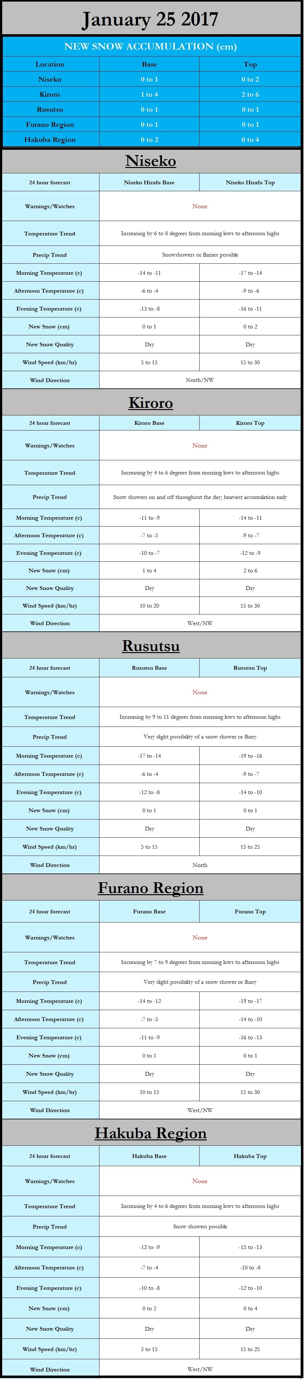
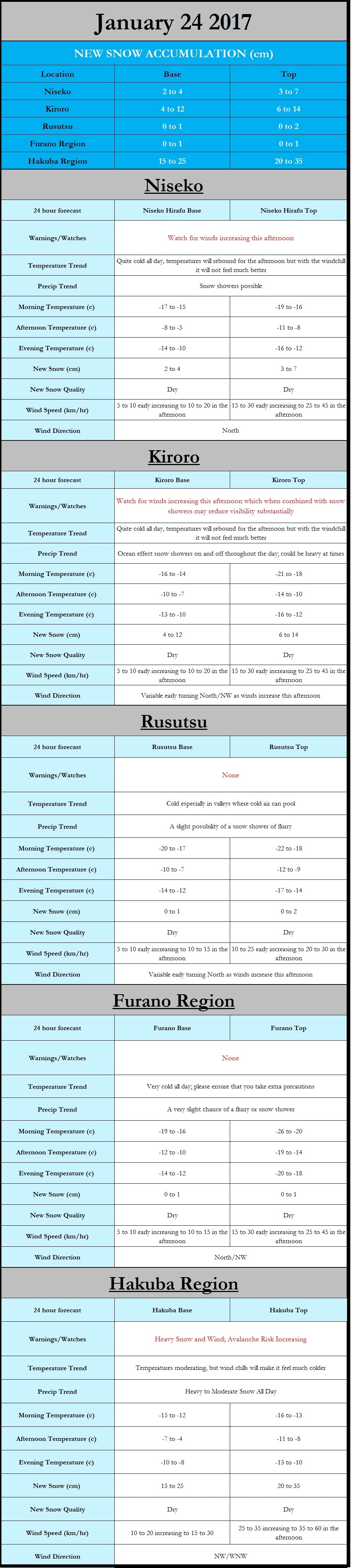
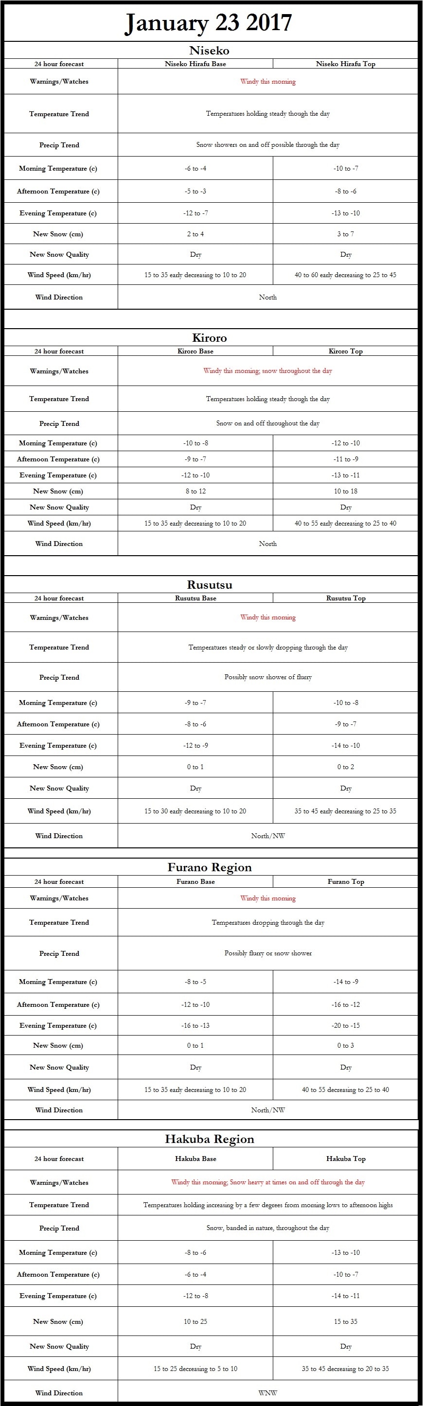
The forecast graphic shows the forecast for the 29th however it is a bit misleading as additional snow will fall overnight and tomorrow. The cause is a weak low pressure system moving northward allowing for the ocean enhanced snow to kick into gear resulting in snow showers increasing in coverage and intensity across not only Hokkaido but also Hakuba. 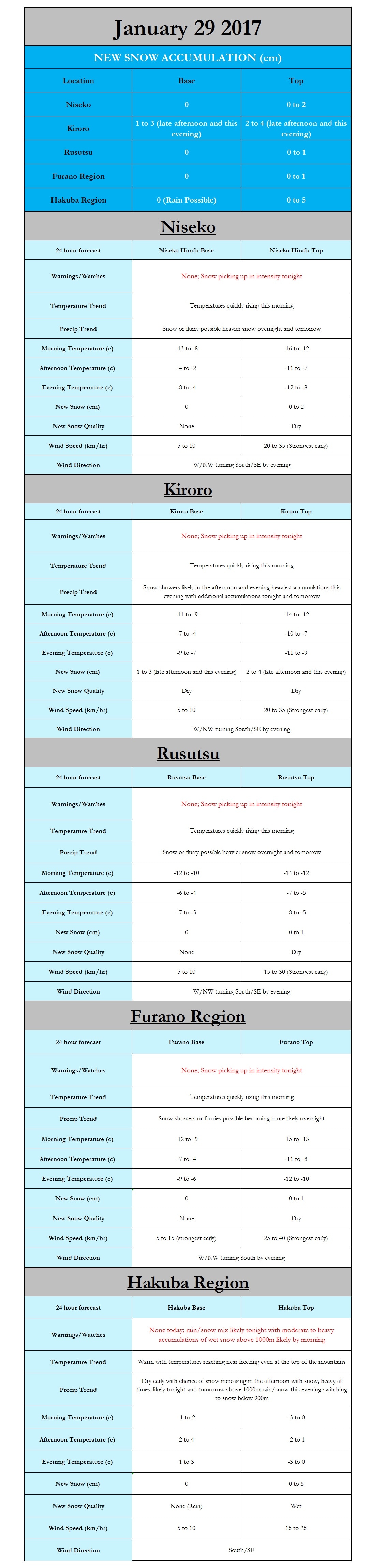 Hi everyone,  Taking a look at the storm that dropped and is currently dropping substantial amounts of snow on the mainland mountains, especially those located towards the eastern side such as the Hakuba region, I am feeling confident that resorts across Hokkaido will be receiving new snow and in some areas substantial amounts. As of present there is a low pressure system located SE of Hokkaido off the eastern coast of the northern mainland. This low pressure will strengthen as it moves slowly NW into the Tsugaru Strait, the body of water separating Honshu and Hokkaido, by this evening. This will push an initial wave of precipitation into the Niseko, Kiroro, and Rusutsu resorts in the late morning/early afternoon and the Furano region in the early afternoon. The initial wave of precipitation will result in the totals I discussed in the January 22nd forecast posted below. However, this is not the end of the storm; the low pressure system associated with the storm will truck off to the northwest towards the Aleutian Islands in Alaska ushering in strong northerly winds across Hokkaido and easterly winds in the Hakuba region. The result is the perfect combination for ocean effect/enhanced snow squalls in both the eastern mainland mountains (Hakuba) and parts of Hokkaido (Kiroro especially). As winds blow across the Sea of Japan to the west of Hakuba they will pick up a substantial amount of moisture which when it encounters the "Japanese Alps", consisting of the Akaishi, Hida, and Kiso mountain ranges, drops snow and often in large amounts and for a prolonged period. This is very likely what we could see this week (FRESH POWDER!!!), with the potential for snow squalls lasting through Wednesday (1/25). So now let’s get to the part we all want to know, snow totals, the biggest issue with this type of system is that the precipitation occurs in bands. Due to the banded nature of the squalls there are wide variations in snowfall. That being said it is quite likely that over the next couple days we will see likely see totals of 30 to 70cm with some areas flirting with +1 meter of snow. Our high resolution model is supporting this and even saying more is possible, the model is hinting at between 35 and 70cm by 2pm tomorrow (1/23), while I think this is excessive for the entire region it is quite possible that areas under persistent bands may see totals of 70cm in 36hrs. Up in Hokkaido totals will be decent across all of the island, however Kiroro will be the big winner with 36hr totals of 35-60cm likely (by 2pm 1/23) and storm totals of 40 to 75. Over the next 36 hours Niseko will receive 20-40cm, Rusutsu 15-20cm, Furano City 20-25cm, Kamui Ski Links 25-35cm, Tomamu Ski 25-35cm, Sahoro 30-40cm, and 35 to 45 on Mt Tokachi. These are fairly conservative numbers and it is possible that higher amounts will occur particularly across the higher elevations so to summarize BE EXCITED!  |
Author
Archives
March 2017
Categories |
 RSS Feed
|
|
Home - Trips - Cat Skiing - Ski Japan - About - Employment - Contact Us
Terms and Conditions - Privacy Policy - Specified Commercial Transaction Act Compliance - Japow Reality Check
Terms and Conditions - Privacy Policy - Specified Commercial Transaction Act Compliance - Japow Reality Check
Japan Ski Tours is an ANTA certified and licensed Japanese travel agency, registered in Tokyo, Japan
Travel Agency License No. 2-6983
Travel Agency License No. 2-6983
Japan Ski Tours, Japan Guides Group Copyright 2019 - 株式会社