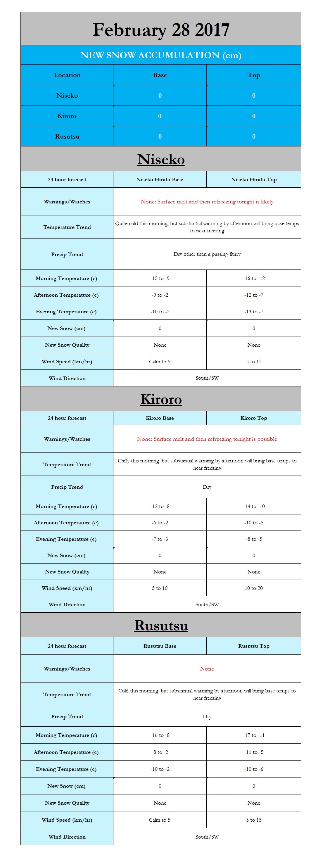
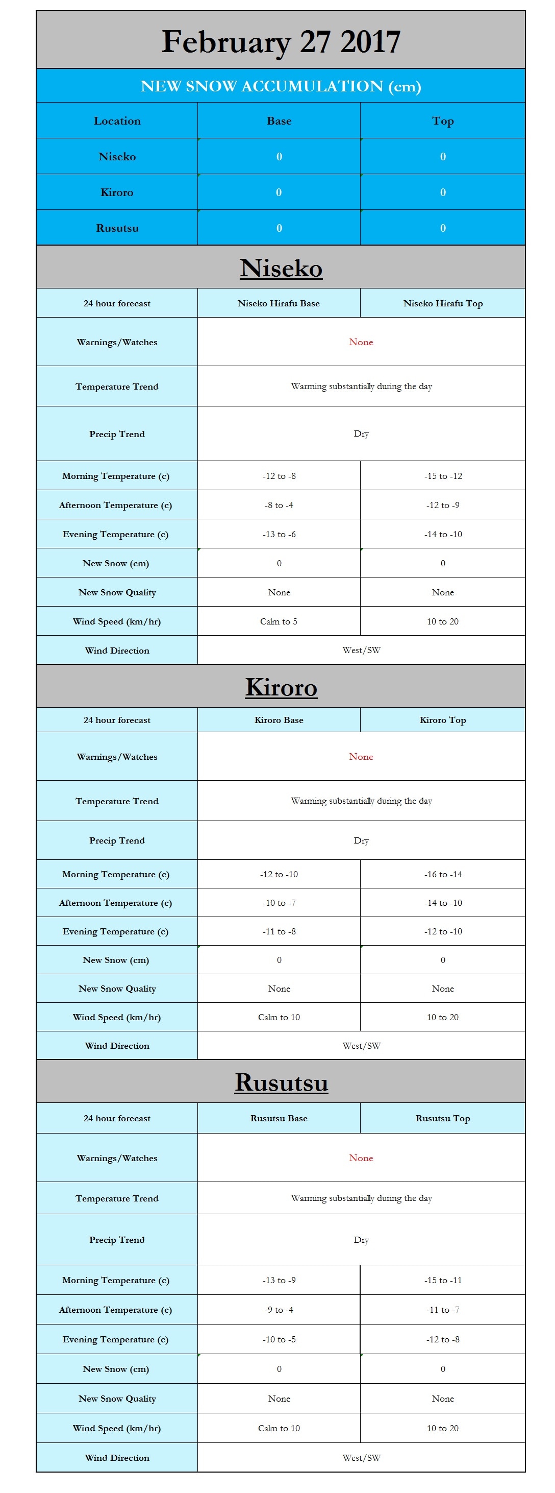
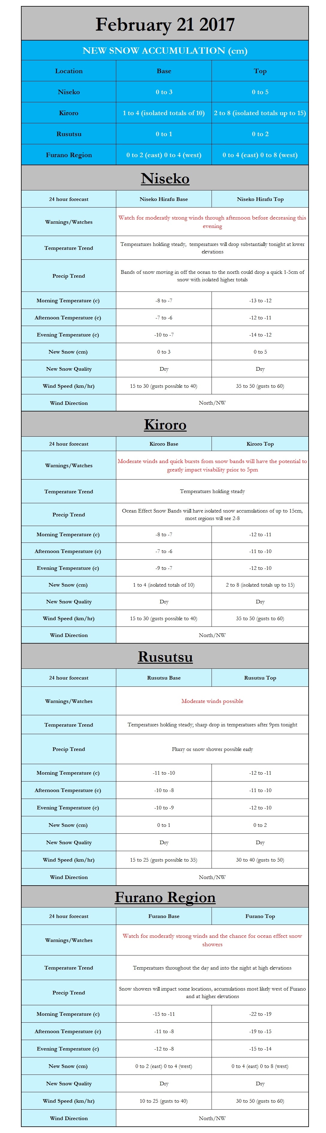
Japan Ski Tours
  • Trips
    • 7-Day Hokkaido Storm Chaser
    • 8-Day Tohoku Storm Chaser
    • Tohoku Indy Trips >
      • 10 Day Tohoku Indy Trip
      • 8 Day Tohoku Indy Trip
    • Epic Pass Rusutsu Package
    • Private Guiding in Tohoku
  • Cat Skiing
    • Hachimantai CAT Skiing
    • Shizukuishi CAT Skiing
  • Ski Japan
    • Ski Tohoku Region
    • Ski Hokkaido
    • Ski Nagano/Niigata
    • When and where to ski Japow
    • Japow Weather Patterns >
      • Japan Powder and La Nina
      • Japan Powder and El Nino
  • About
    • Japan Ski Tours
    • Our Team
    • In the Press
    • Reviews
    • Skier ability level
    • COVID-19
  • Contact Us

February 28th Forecast Graphic

2/28/2017

0 Comments

 
Picture
0 Comments

February 27th Forecast Graphic

2/27/2017

0 Comments

 
Picture
0 Comments

February 26th Forecast Graphic

2/26/2017

0 Comments


Hi all,

I have a fairly wide range in possible new snow accumulation for both Kiroro and the Furano Region as the potential for isolated ocean effect snow bands is present. It is a situation where it will be hit or miss. If you are under a snow band there will be a decent little snow event over a short period, however many areas will end up with no new accumulation.

​Paul

Picture
0 Comments

February 26th (12am-4pm) New Snow Accumulation Map 

2/26/2017

0 Comments

 
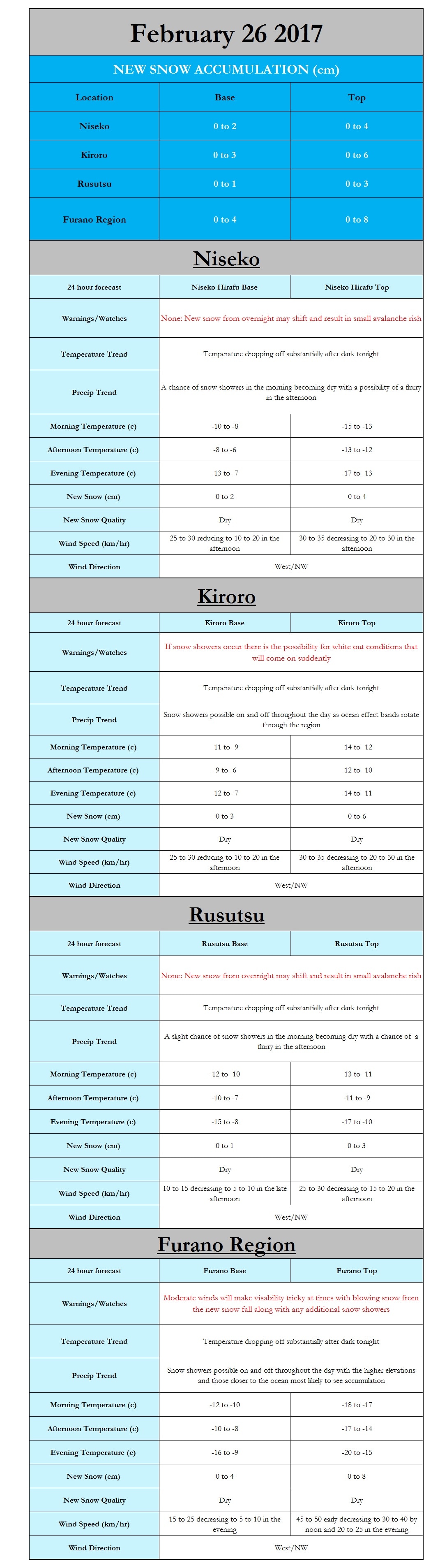
Hi all, our in-house high resolution model here at japanskitours.com is attempting to capture the impact of the ocean effect snow showers by dropping some some fresh snow with accumulations of 10-15+ cm across the interior mountains of Hokkaido to the east of line from Asahikawa to Furano. Another area of interest is out towards Kiroro, where I am expecting 6-12+ cm of that famous JAPOW. Although the model is not quite picking up on this yet, I do see multiple indicators that a new snow band will soon develop and come onshore leading to several cm of accumulations before the sunrises, which will only add onto the 10-20+ cm reports that came in for the Kiroro region yesterday. Niseko surprised my yesterday with some heavy snow showers hammering the region from 5:30pm-11pm. At only 100m above sea level the observation station in Niseko reported 10mm of liquid precipitation in those 4.5hrs, which should easily have resulted in 8 to 16cm of snow for the city. The surrounding mountains likely received at least 12 to 25cm from this evening burst. Rusutsu was another surprise with the evening burst of snow driven by southerly winds putting down additional snow.

So my adivce is to get out there, hit the slopes early before the rest of the crowd and whether up north in Furano, out west in Kiroro, or south in Rusutsu enjoy the powder day!
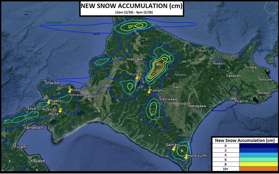
Picture
0 Comments

February 25th Forecast Graphic

2/25/2017

0 Comments

 
Picture
0 Comments

February 24th Forecast Graphic

2/24/2017

0 Comments

 
Hi all,
​
I hope you all are enjoying the new snow that has fallen across Hokkaido. Currently, the winds are quite gusty across the eastern coast north of the city of Hokkaido, with the coastal city of Rumoi reporting sustained winds of over 50km/hr. These winds are likely even stronger in the mountains around Asahikawa and Furano, which may result in some issues with lifts being open. In addition to the winds there are ongoing snow squalls moving in from the east which will further cause issues with visibility. A weak low pressure system to our north will help to enhance these snow showers to an extent allowing them to continue on and off across the eastern portions of Hokkaido for the next several days with accumulation likely. The last of the snow should end sometime Sunday as a high pressure system moves in, bringing clearing skies. Looking ahead the next system appears to be in place to impact Hokkaido starting around the 1st of March, currently it is too early to make accurate predictions, but it does appear that this system may have more warm air to work with. If the warmer situation materializes it is quite possible that lower elevations may see an extended period of rain with higher elevations seeing a rain/snow mix. 


Paul
Picture
0 Comments

February 23rd Forecast Graphic: Hokkaido SNOW!!!! 

2/23/2017

0 Comments

 
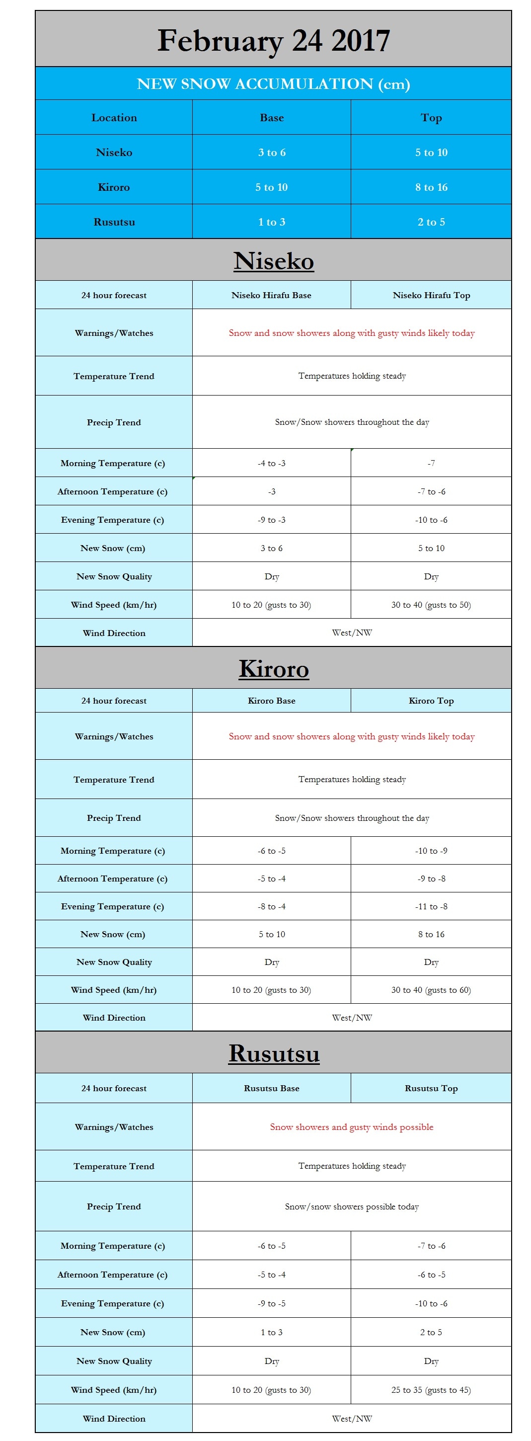
Hi all,

A Quick Note: The Forecast Graphic only accounts for snow accumulations up to 10pm tonight. The majority of the snow will fall after 7/8pm tonight. Whereas the New Snow Accumulation map accounts for new snow accumulations until noon tomorrow. Winds Will be very strong late tonight and into tomorrow, especially on the west side of Hokkaido. Lifts may shut down at times in the Furano Region tomorrow.

​Paul
Picture
Picture
0 Comments

Forecasting a Messy Mix of Rain, Snow, and Wind Slamming Hakuba. Is Hokkaido Next?

2/23/2017

0 Comments


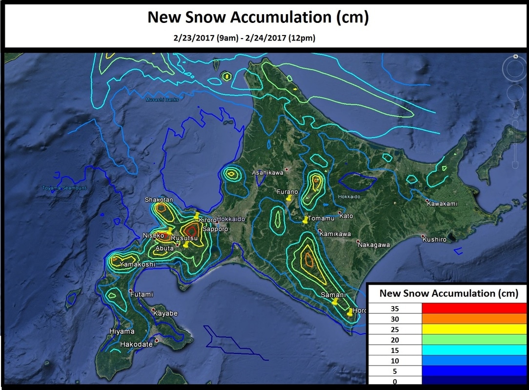
​It was quite a rollercoaster yesterday (2/22/17) in the Hakuba Region and is getting very messy now that the clock has struck midnight. In fact the reporting station in Hakuba, which is situated at roughly the same elevation as many of the bases (700m above sea level), has reported a very wet almost slushy 5cm of new snow in the past hour, with more expected overnight. The rollercoaster ride began this morning with a chilly morning low of -13.3C before rocketing up by an incredible 17.9 degrees by early afternoon, when at 1pm the high temperature reached 4.6C. To put this into perspective for those who use the imperial system, it equates to a morning low of 8F and an afternoon high of 40F (32 degree increase). While the rollercoaster ride of temperatures was sure to cause some issues with snow conditions at low and middle elevations the real story just started developing in the late evening hours of the 22nd as a low pressure system has rapidly strengthened bringing very heavy precipitation. This should be good news for the slopes, right? In this case in might not be, I am quite concerned about the quality of snow and the possibility of a rain/snow mix which might degrade the current snow pack. 


Mountain forecasting is notoriously difficult, but this is even more challenging. The currently available data which I feed into our in-house models is, to put it bluntly, worthless. However, using the reliable available data I feel very confident in stating that by late tonight (2/23/17) substantial precipitation will fall across the Hakuba Region. 25 to 50mm of liquid precipitation is expected for almost every location, with some locations likely approaching 75mm. Looking at the current radar there are exceptionally impressive returns for this time of the year with locations 150-200km to the SW of Hakuba reporting observations of 5 to 12mm in the past hour, even further to the SE the hills outside of Kochi have reported 20mm in the past hour. If this intense moisture can make its way into the mountains around Hakuba and temperatures remain cold enough to support snow, there could be very impressive totals albeit of very wet quality. With all of that being said I see a decent snow event for elevations above 1200m with totals of 15 to 30cm, but it will be very wet. I must mention that with the strong winds, wet snow, warm temperatures, and rain the avalanche risk has increased. 


Most of you reading this are probably planning to hit one of the many slopes on the beautiful island of Hokkaido, so enough of the suspense let’s talk snow. The situation in Hokkaido looks amazing! This storm will not be a record breaker by any means, but unlike Hakuba the temperatures across Hokkaido will be cold enough to support snow and on average you should be able to enjoy some new dry or dry/heavy quality snow. The strength of this system is impressive and assuming it becomes a “double barrel low” as I am predicting the entire island will receive snow.


At the moment the SE coast and resorts such as Rusutsu and Tomamu will receive the majority of their snow starting late this morning/early this afternoon and continuing overnight into the early morning hours of Friday (2/24/2017) as one of the lows tracks along the SE coast of Hokkaido. Niseko is in an interesting situation as it is starring down both “barrels” of this system, with impacts expected from both low pressure systems and also the potential for ocean effect snow. At the moment I would expect snow to become heaviest this afternoon and into tomorrow, with a possible break in the snow this evening/overnight. Kiroro and Furano will be the last to arrive to the party, but they will be the big winners from this event. While he majority of the snow in these locations will hold off until after dark this evening when it does arrive in earnest extremely strong winds will drop visibilities to near zero. The threat of moderate to heavy snow will persist well into Friday as ocean effect bands kick in. 

With how messy the situation is for Hakuba and has the potential to be for Hokkaido I will delay issuing an official forecast until the new data comes in. Please check back for an updated official graphical forecast around 730am (2/23/17) followed by snowfall graphics from our in-house weather model! 


​Paul

0 Comments

February 22nd Forecast Graphic

2/22/2017

0 Comments

 
Picture
0 Comments

February 21st Forecast Graphic

2/21/2017

0 Comments

 
Picture
0 Comments
<<Previous

    Author


    Paul Carlone, is a meteorologist specializing in the financial, energy, and agricultural sectors.  He has consulted or worked with the commodity, agricultural, aerospace, hydrological, and meteorology communities although he also now specializes in forecasting where the Japow will come rolling in. 

    Archives

    March 2017
    February 2017
    January 2017
    December 2016
    November 2016

    Categories

    All

    RSS Feed

Home - Trips - Cat Skiing - Ski Japan - About - Employment - Contact Us 
Terms and Conditions - Privacy Policy - Specified Commercial Transaction Act Compliance - Japow Reality Check
Picture
Japan Ski Tours is an ANTA certified and licensed Japanese travel agency, registered in Tokyo, Japan
Travel Agency License No. 2-6983
Japan Ski Tours, Japan Guides Group Copyright 2019 - ​株式会社 ​
  • Trips
    • 7-Day Hokkaido Storm Chaser
    • 8-Day Tohoku Storm Chaser
    • Tohoku Indy Trips >
      • 10 Day Tohoku Indy Trip
      • 8 Day Tohoku Indy Trip
    • Epic Pass Rusutsu Package
    • Private Guiding in Tohoku
  • Cat Skiing
    • Hachimantai CAT Skiing
    • Shizukuishi CAT Skiing
  • Ski Japan
    • Ski Tohoku Region
    • Ski Hokkaido
    • Ski Nagano/Niigata
    • When and where to ski Japow
    • Japow Weather Patterns >
      • Japan Powder and La Nina
      • Japan Powder and El Nino
  • About
    • Japan Ski Tours
    • Our Team
    • In the Press
    • Reviews
    • Skier ability level
    • COVID-19
  • Contact Us