Japan Ski Tours
  • Trips
    • 7-Day Hokkaido Storm Chaser
    • 8-Day Tohoku Storm Chaser
    • Tohoku Indy Trips >
      • 10 Day Tohoku Indy Trip
      • 8 Day Tohoku Indy Trip
    • Epic Pass Rusutsu Package
    • Private Guiding in Tohoku
  • Cat Skiing
    • Hachimantai CAT Skiing
    • Shizukuishi CAT Skiing
  • Ski Japan
    • Ski Tohoku Region
    • Ski Hokkaido
    • Ski Nagano/Niigata
    • When and where to ski Japow
    • Japow Weather Patterns >
      • Japan Powder and La Nina
      • Japan Powder and El Nino
  • About
    • Japan Ski Tours
    • Our Team
    • In the Press
    • Reviews
    • Skier ability level
  • Contact Us

February 20th Forecast Graphic and Snowstorm Update with Model Output Map

2/20/2017

1 Comment


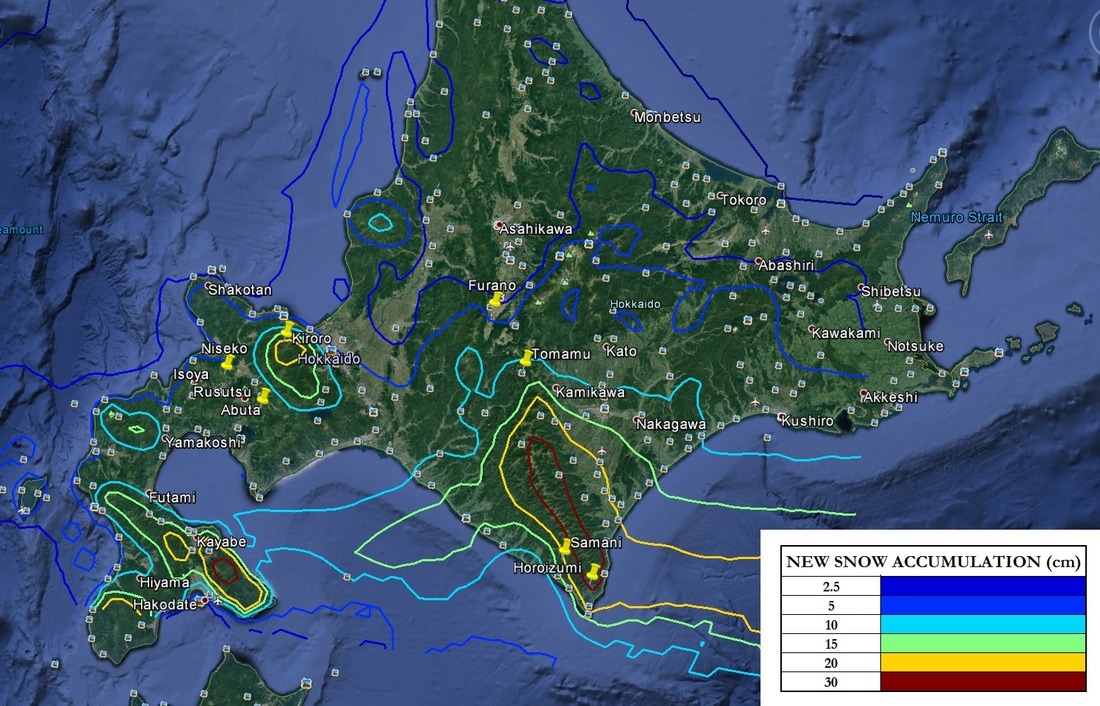
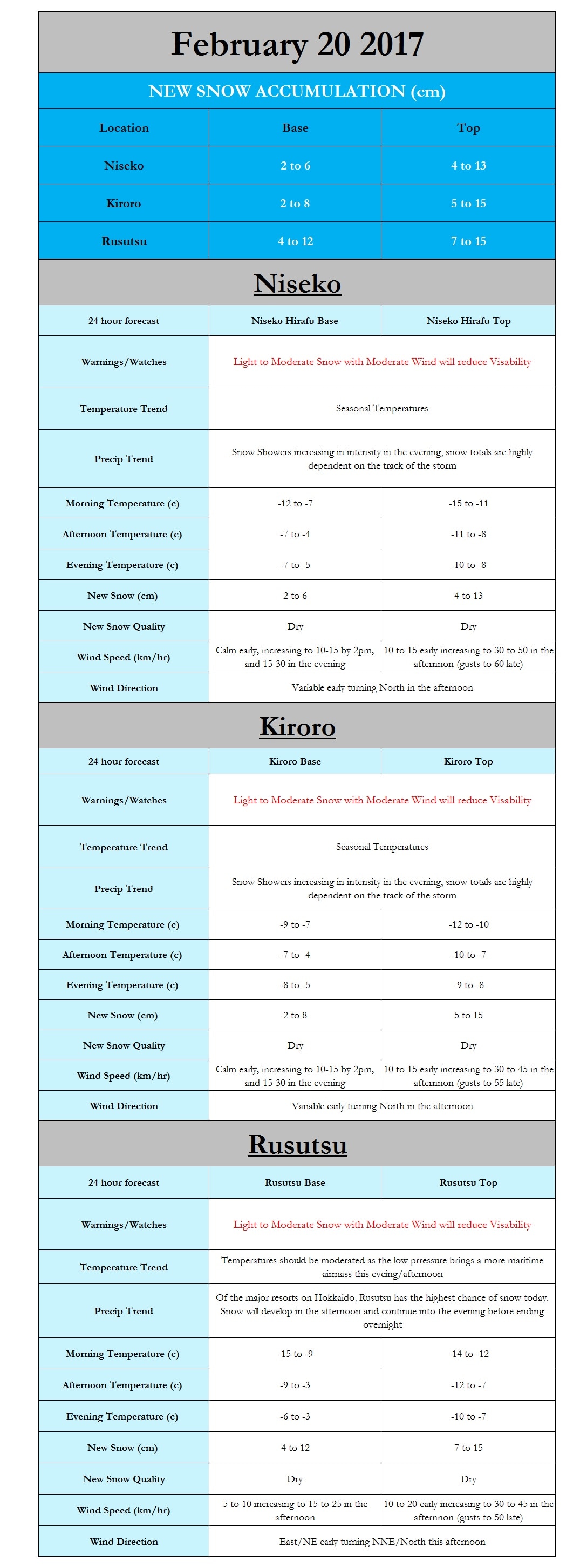
I hope everyone enjoyed their weekend and is ready to start another great day on the slopes across Hokkaido. Our next snowstorm is slowly edging its merry way towards Hokkaido, apparently unaware that it is not doing what was previously expected. That being said there is a shift in the forecast for both timing and snow totals. The onset of snow will likely be delayed by 4-6hrs with snow showers starting to impact Niseko, Kiroro, and Rusutsu in the mid to late afternoon. I am personally leaning towards the heaviest snow totals of these three occurring around Rusutsu, but a small shift in storm track or the onset of ocean effect/enhanced snow could greatly increase snow totals especially in Kiroro

I mentioned yesterday a sharp gradient in snow totals for those up in Furano and this sadly appears to be only getting worse with the gradient shifting south. As a result those in Furano and North/NW will likely see very little snow from this system. However, as the winds shift tomorrow the potential for ocean effect snow will develop. To the South and SE of Furano the likelihood of snow and snow totals increase with locations such as Tomamu possibly receiving as much as 15 to 25cm.

Below is a graphic from our in-house model here at Japanskitours.com displaying the modeled new snow accumulation (cm) using a snow ratio equation that I consider conservative. This is not a forecast but I wanted to show you how tight the gradient is between moderate/heavy accumulations and very little at all.

 Paul

Japanskitours.com In-House Model

24hr New Snow Accumulation (cm) February 20th

Picture

Picture
1 Comment
Damien Daniels link
6/26/2022 09:43:23 pm

Hi thanks for sharing thiss

Reply


Leave a Reply.

    Author


    Paul Carlone, is a meteorologist specializing in the financial, energy, and agricultural sectors.  He has consulted or worked with the commodity, agricultural, aerospace, hydrological, and meteorology communities although he also now specializes in forecasting where the Japow will come rolling in. 

    Archives

    March 2017
    February 2017
    January 2017
    December 2016
    November 2016

    Categories

    All

    RSS Feed

Home - Trips - Cat Skiing - Ski Japan - About - Employment - Contact Us 
Terms and Conditions - Privacy Policy - Specified Commercial Transaction Act Compliance - Japow Reality Check
Picture
Japan Ski Tours is an ANTA certified and licensed Japanese travel agency, registered in Tokyo, Japan
Travel Agency License No. 2-6983
Japan Ski Tours, Japan Guides Group Copyright 2019 - ​株式会社 ​
  • Trips
    • 7-Day Hokkaido Storm Chaser
    • 8-Day Tohoku Storm Chaser
    • Tohoku Indy Trips >
      • 10 Day Tohoku Indy Trip
      • 8 Day Tohoku Indy Trip
    • Epic Pass Rusutsu Package
    • Private Guiding in Tohoku
  • Cat Skiing
    • Hachimantai CAT Skiing
    • Shizukuishi CAT Skiing
  • Ski Japan
    • Ski Tohoku Region
    • Ski Hokkaido
    • Ski Nagano/Niigata
    • When and where to ski Japow
    • Japow Weather Patterns >
      • Japan Powder and La Nina
      • Japan Powder and El Nino
  • About
    • Japan Ski Tours
    • Our Team
    • In the Press
    • Reviews
    • Skier ability level
  • Contact Us