|
Hi all,
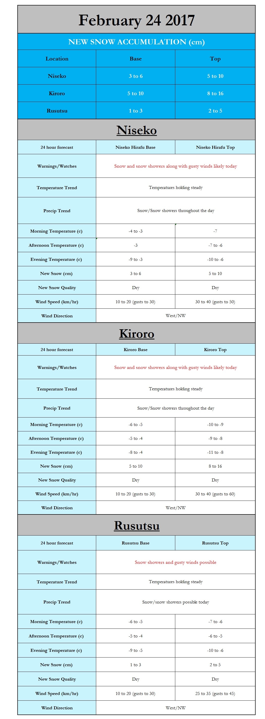
I hope you all are enjoying the new snow that has fallen across Hokkaido. Currently, the winds are quite gusty across the eastern coast north of the city of Hokkaido, with the coastal city of Rumoi reporting sustained winds of over 50km/hr. These winds are likely even stronger in the mountains around Asahikawa and Furano, which may result in some issues with lifts being open. In addition to the winds there are ongoing snow squalls moving in from the east which will further cause issues with visibility. A weak low pressure system to our north will help to enhance these snow showers to an extent allowing them to continue on and off across the eastern portions of Hokkaido for the next several days with accumulation likely. The last of the snow should end sometime Sunday as a high pressure system moves in, bringing clearing skies. Looking ahead the next system appears to be in place to impact Hokkaido starting around the 1st of March, currently it is too early to make accurate predictions, but it does appear that this system may have more warm air to work with. If the warmer situation materializes it is quite possible that lower elevations may see an extended period of rain with higher elevations seeing a rain/snow mix. Paul
0 Comments
Leave a Reply. |
Author
Archives
March 2017
Categories |
|
|
Home - Trips - Cat Skiing - Ski Japan - About - Employment - Contact Us
Terms and Conditions - Privacy Policy - Specified Commercial Transaction Act Compliance - Japow Reality Check
Terms and Conditions - Privacy Policy - Specified Commercial Transaction Act Compliance - Japow Reality Check
Japan Ski Tours is an ANTA certified and licensed Japanese travel agency, registered in Tokyo, Japan
Travel Agency License No. 2-6983
Travel Agency License No. 2-6983
Japan Ski Tours, Japan Guides Group Copyright 2019 - 株式会社


 RSS Feed
