|
Hi all, our in-house high resolution model here at japanskitours.com is attempting to capture the impact of the ocean effect snow showers by dropping some some fresh snow with accumulations of 10-15+ cm across the interior mountains of Hokkaido to the east of line from Asahikawa to Furano. Another area of interest is out towards Kiroro, where I am expecting 6-12+ cm of that famous JAPOW. Although the model is not quite picking up on this yet, I do see multiple indicators that a new snow band will soon develop and come onshore leading to several cm of accumulations before the sunrises, which will only add onto the 10-20+ cm reports that came in for the Kiroro region yesterday. Niseko surprised my yesterday with some heavy snow showers hammering the region from 5:30pm-11pm. At only 100m above sea level the observation station in Niseko reported 10mm of liquid precipitation in those 4.5hrs, which should easily have resulted in 8 to 16cm of snow for the city. The surrounding mountains likely received at least 12 to 25cm from this evening burst. Rusutsu was another surprise with the evening burst of snow driven by southerly winds putting down additional snow. So my adivce is to get out there, hit the slopes early before the rest of the crowd and whether up north in Furano, out west in Kiroro, or south in Rusutsu enjoy the powder day! 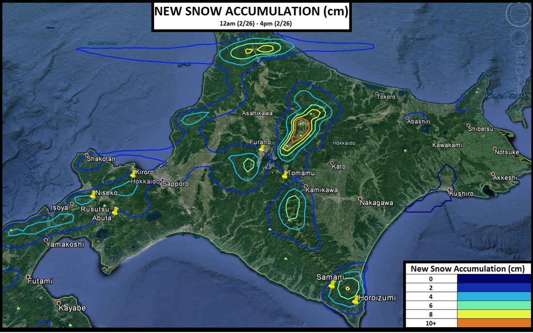
0 Comments
Leave a Reply. |
Author
Archives
March 2017
Categories |
 RSS Feed
|
|
Home - Trips - Cat Skiing - Ski Japan - About - Employment - Contact Us
Terms and Conditions - Privacy Policy - Specified Commercial Transaction Act Compliance - Japow Reality Check
Terms and Conditions - Privacy Policy - Specified Commercial Transaction Act Compliance - Japow Reality Check
Japan Ski Tours is an ANTA certified and licensed Japanese travel agency, registered in Tokyo, Japan
Travel Agency License No. 2-6983
Travel Agency License No. 2-6983
Japan Ski Tours, Japan Guides Group Copyright 2019 - 株式会社