Japan Ski Tours
  • Trips
    • 7-Day Hokkaido Storm Chaser
    • 8-Day Tohoku Storm Chaser
    • Tohoku Indy Trips >
      • 10 Day Tohoku Indy Trip
      • 8 Day Tohoku Indy Trip
    • Epic Pass Rusutsu Package
    • Private Guiding in Tohoku
  • Cat Skiing
    • Hachimantai CAT Skiing
    • Shizukuishi CAT Skiing
  • Ski Japan
    • Ski Tohoku Region
    • Ski Hokkaido
    • Ski Nagano/Niigata
    • When and where to ski Japow
    • Japow Weather Patterns >
      • Japan Powder and La Nina
      • Japan Powder and El Nino
  • About
    • Japan Ski Tours
    • Our Team
    • In the Press
    • Reviews
    • Skier ability level
  • Contact Us

January 11th forecast: Snow, Wind, Avalanche Risk 

1/11/2017

0 Comments


If you enjoy snow, as I think all of us reading this forecast do, today is the day for you. Well to be honest the next couple days should be quite snowy, making those across SW Hokkaido quite happy. However, I am concerned about the winds especially today across the higher elevations. Currently, there are advisories out for heavy snow, winds, and the possibility of avalanches. Temperatures at midnight are already well below zero (Makkari reporting -10.4) with colder temperatures in the mountains and cold air drainage regions. I expect temperatures to drop further, however the clouds and falling snow should help moderate the decrease to some extent resulting in morning lows of -15 to -8 across the lower regions while mountain tops will drop into the -22 to -13 range.

The greatest concern is the winds which as of midnight are already quite strong with sustained WNW winds of 30-40km/hr being recorded at lower elevations. These winds should further increase during the days possibly reaching 45km/hr across the cities and 50km/hr at mountain bases. While those wind speeds are quite strong there is a legitimate potential across the higher elevations to see winds that are extremely dangerous. Taking a look at the 850mb (correlates to ~1300m today) model wind speeds I am noticing 55 to 70km/hr sustained winds with even greater winds possible on the higher NW and WNW facing slopes. This will create white out conditions both during periods of snow and also from so called “ground blizzards” where dry freshly fallen snow is whipped up by the wind dropping visibility substantially.

The other big concern comes from avalanches. As you recall we had some warm sunny days followed by cold nights, this resulted in some melting and refreezing of the surface layer of snow. This has resulted in a layer of weak snow in some areas. As additional snow falls upon this layer the avalanche risk increases exponentially, specifically in the backcountry. Enjoy the snow but please take the appropriate caution with this new snow and stay aware of your surroundings. Between this morning (January 11th) and the morning of Friday (January 13th), there may be some locations that see 35-40+ cm of snow; these locations would be the highest W/NW facing slopes and mountain tops. I expect that most locations above 1000m will see at least 25cm with lower elevations still seeing some nice snowfall. The best part may be my current outlook for the snow quality, predominantly dry! 

For those who have been interested in the high resolution model the data feed is slowly coming back online, it is my hope to be able to post additional graphics from it this week! Enjoy the snow and stay safe, both of the roads and the slopes!


Picture
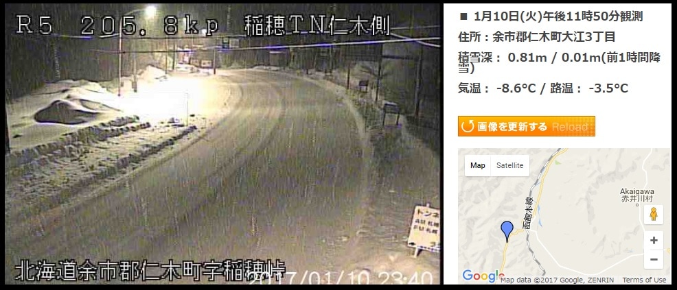
Check out this image of the snow falling at midnight! This camera is located west of Akaigawa on Japan National Route 5 260m above sea level! 

(Courtesy of http://www.hbc.co.jp/)

Picture
0 Comments


Leave a Reply.

    Author


    Paul Carlone, is a meteorologist specializing in the financial, energy, and agricultural sectors.  He has consulted or worked with the commodity, agricultural, aerospace, hydrological, and meteorology communities although he also now specializes in forecasting where the Japow will come rolling in. 

    Archives

    March 2017
    February 2017
    January 2017
    December 2016
    November 2016

    Categories

    All

    RSS Feed

Home - Trips - Cat Skiing - Ski Japan - About - Employment - Contact Us 
Terms and Conditions - Privacy Policy - Specified Commercial Transaction Act Compliance - Japow Reality Check
Picture
Japan Ski Tours is an ANTA certified and licensed Japanese travel agency, registered in Tokyo, Japan
Travel Agency License No. 2-6983
Japan Ski Tours, Japan Guides Group Copyright 2019 - ​株式会社 ​
  • Trips
    • 7-Day Hokkaido Storm Chaser
    • 8-Day Tohoku Storm Chaser
    • Tohoku Indy Trips >
      • 10 Day Tohoku Indy Trip
      • 8 Day Tohoku Indy Trip
    • Epic Pass Rusutsu Package
    • Private Guiding in Tohoku
  • Cat Skiing
    • Hachimantai CAT Skiing
    • Shizukuishi CAT Skiing
  • Ski Japan
    • Ski Tohoku Region
    • Ski Hokkaido
    • Ski Nagano/Niigata
    • When and where to ski Japow
    • Japow Weather Patterns >
      • Japan Powder and La Nina
      • Japan Powder and El Nino
  • About
    • Japan Ski Tours
    • Our Team
    • In the Press
    • Reviews
    • Skier ability level
  • Contact Us