Japan Ski Tours
  • Trips
    • 7-Day Hokkaido Storm Chaser
    • 8-Day Tohoku Storm Chaser
    • Tohoku Indy Trips >
      • 10 Day Tohoku Indy Trip
      • 8 Day Tohoku Indy Trip
    • Epic Pass Rusutsu Package
    • Private Guiding in Tohoku
  • Cat Skiing
    • Hachimantai CAT Skiing
    • Shizukuishi CAT Skiing
  • Ski Japan
    • Ski Tohoku Region
    • Ski Hokkaido
    • Ski Nagano/Niigata
    • When and where to ski Japow
    • Japow Weather Patterns >
      • Japan Powder and La Nina
      • Japan Powder and El Nino
  • About
    • Japan Ski Tours
    • Our Team
    • In the Press
    • Reviews
    • Skier ability level
  • Contact Us

January 12th forecast graphic: Snow and wind 

1/12/2017

0 Comments


Hi all,

Today looks to have more snow and quite a bit of wind especially at the higher elevations of Hokkaido. The snow is banded in nature, coming in strips off of the ocean to the west, meaning there will be periods where it is snowing and other periods of dry but cloudy. The banded nature also means that the predicted snowfall may end up not occuring. As I look at the current radar there is heavy snow falling in a east to west band off the coast to the north of Otaru. I am going to be optimistic though and predict that the snow bands will develop over the 3 major resort regions.

With respect to the banded nature of the snow be aware that in the heavier snow bands white outs are a possibility and with the new snow please stay aware for avalanches. Additionally, check ahead to ensure the route to your preferred slope is open; on Monday in the United States a large avalanche shut down I-70 in Colorado. The winds and snow rates will slowly decrease in the evening across the island.

Below is the high resolution model output for new snowfall from midnight January 12th to 9pm January 12th. This is only a model output not a forecast. Please see the forecast graphic below the snowfall graphic for a forecast.
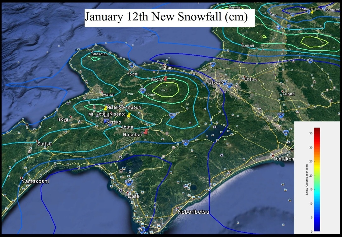
The model has a finite spatial resolution (it does not predict for every square inch of Hokkaido). That is where I come into play by taking into account elevation, location, etc to make a forecast.

I do want to draw your attention to the 28cm+ snowfall SE of Kiroro. The higher elevations in the Kiroro could pick up as much as 30cm. Personally I went with a 15-25cm total due to multiple factors. If you are down on the SE tip of Hokkaido near Horoizumi the higher elevations could really be hammered (model output showing 40cm). 

​Paul


Picture

Picture
0 Comments


Leave a Reply.

    Author


    Paul Carlone, is a meteorologist specializing in the financial, energy, and agricultural sectors.  He has consulted or worked with the commodity, agricultural, aerospace, hydrological, and meteorology communities although he also now specializes in forecasting where the Japow will come rolling in. 

    Archives

    March 2017
    February 2017
    January 2017
    December 2016
    November 2016

    Categories

    All

    RSS Feed

Home - Trips - Cat Skiing - Ski Japan - About - Employment - Contact Us 
Terms and Conditions - Privacy Policy - Specified Commercial Transaction Act Compliance - Japow Reality Check
Picture
Japan Ski Tours is an ANTA certified and licensed Japanese travel agency, registered in Tokyo, Japan
Travel Agency License No. 2-6983
Japan Ski Tours, Japan Guides Group Copyright 2019 - ​株式会社 ​
  • Trips
    • 7-Day Hokkaido Storm Chaser
    • 8-Day Tohoku Storm Chaser
    • Tohoku Indy Trips >
      • 10 Day Tohoku Indy Trip
      • 8 Day Tohoku Indy Trip
    • Epic Pass Rusutsu Package
    • Private Guiding in Tohoku
  • Cat Skiing
    • Hachimantai CAT Skiing
    • Shizukuishi CAT Skiing
  • Ski Japan
    • Ski Tohoku Region
    • Ski Hokkaido
    • Ski Nagano/Niigata
    • When and where to ski Japow
    • Japow Weather Patterns >
      • Japan Powder and La Nina
      • Japan Powder and El Nino
  • About
    • Japan Ski Tours
    • Our Team
    • In the Press
    • Reviews
    • Skier ability level
  • Contact Us