Japan Ski Tours
  • Trips
    • 7-Day Hokkaido Storm Chaser
    • 8-Day Tohoku Storm Chaser
    • Tohoku Indy Trips >
      • 10 Day Tohoku Indy Trip
      • 8 Day Tohoku Indy Trip
    • Epic Pass Rusutsu Package
    • Private Guiding in Tohoku
  • Cat Skiing
    • Hachimantai CAT Skiing
    • Shizukuishi CAT Skiing
  • Ski Japan
    • Ski Tohoku Region
    • Ski Hokkaido
    • Ski Nagano/Niigata
    • When and where to ski Japow
    • Japow Weather Patterns >
      • Japan Powder and La Nina
      • Japan Powder and El Nino
  • About
    • Japan Ski Tours
    • Our Team
    • In the Press
    • Reviews
    • Skier ability level
  • Contact Us

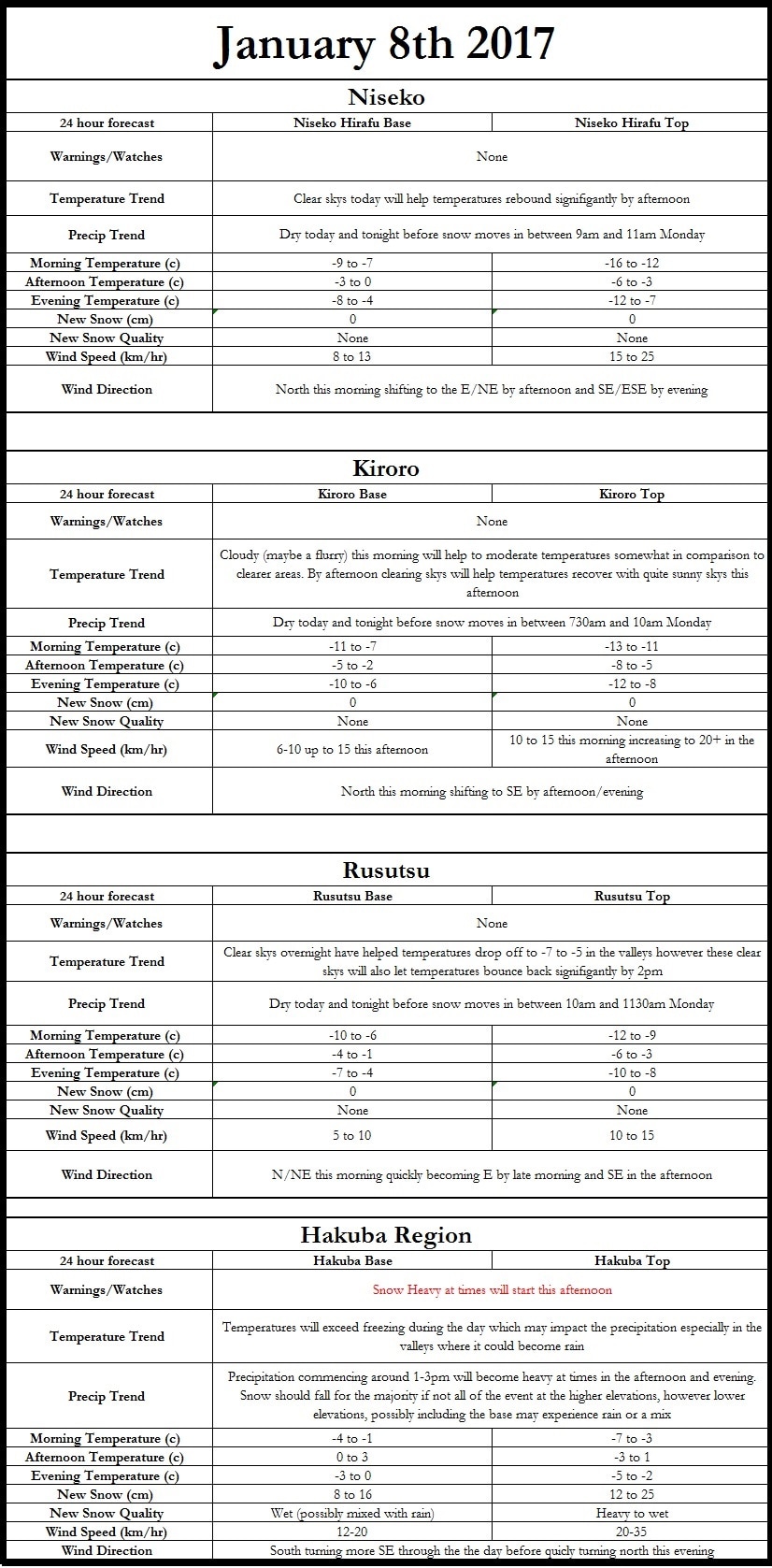
January 8th forecast graphic, snow map, and write up

1/8/2017

0 Comments


​Hi all! As it is finally the weekend here in the United States I have more time to really delve into the forecast so let’s take a look at both the short and long range forecast. Also any reports, especially temperature and wind speeds, you experience at the base and top of the mountains would be much appreciated. When adjusting models and making forecasts these come in very handy.
Taking a look at current conditions, I am watching a low pressure system strengthening just off the SE coast of Japan for development through the day. This looks to bring snow to the Hakuba region of central Japan, where Luke is currently testing out the slope. Winds will be blowing quite hard across mainland Japan this morning with coastal sections of SE Japan possibly reaching 60km/h. If you have a flight coming into or out of Tokyo it will become increasingly messy as the day progresses. Winds this morning out of the northeast at 15-25 km/h will increase to 35-45+ km/h by afternoon and precipitation moving in from the south. In contrast Hokkaido is currently sitting under a fairly strong high pressure system, with light winds (3-10 km/h) out of the N/NW (unless you are in the higher elevations where you will see winds of 25-35 km/h) this morning.

As we progress into the afternoon the high over Hokkaido will slowly weaken and meander its way off to the east, centered over Akkeshi by evening. This should bring really nice conditions to the entirety of Hokkaido today with lows of -20C across the highest mountains and highs of around freezing and above across the coastal and low lying regions (highs in the mountain of -12 to -8C). This is quite the disparity from mainland Japan where the surface low will rapidly intensify; bringing rain, snow, and gusty winds as it moves northeast. Snow should commence in the Mt Norikura and Mt. Hotaka, to the south of Hakuba, by 2pm with the first flakes falling across the Hakuba region in the 230-330pm period. Snow rates will rapidly intensify during the evening with white out conditions expected on and off between 8pm and 3am before the snow tapers off by mid-morning tomorrow (1/9/17). At present I am waiting for the newest high resolution model data to come in, but I am fairly confident in totals of 20-40cm for Hakuba with higher amounts likely on the higher peaks. I am concerned with rain mixing in across lower elevations possibly cutting into the totals. Judging by vertical temperature profiles I expect the snow to start off heavy and progressively becoming wetter during the night, due to warmer mid-level temperatures of 0 to -3C advecting in.

As this powerful system moves N/NE along the mainland coast precipitation will start to become more likely for Hokkaido; Rusutsu could see snow as early as 6am Monday morning. Snow will overspread the entirety of SW Hokkaido somewhere between 11am-1pm and progressing into the evening before snow tapers off from SW to NE during the night; resulting in totals of 15-35cm. That is not the end of the snow though, winds whipping out of the NW will usher in more snow showers, at times quite heavy for both SW Hokkaido and the Hakuba on the mainland. This could be quite a prolonged for both areas bringing some much needed snow to the ski resorts. I am still working on putting together a high resolution model for the Hakuba region, which will hopefully help bring forecasts to even more skiers out there.


Picture

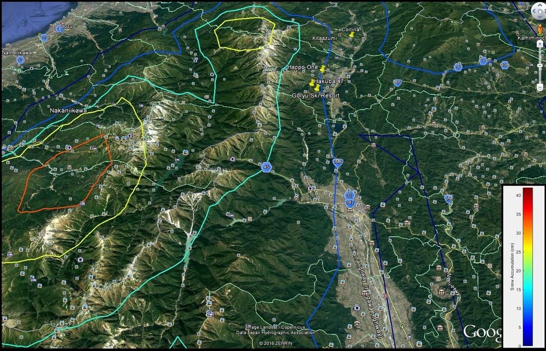
Here is a quick little glimpse at the snow totals from one of the snow fall models that I have put together for Hakuba Region. It is struggling to handle the elevation and mid-level temperatures but as you can see the highest snow will fall in the highest elevations west of Hakuba. However the higher runs in Hakuba 47 and Goryu should see snow totals exceeding 25cm. The city of Hakuba could get nasty at times with rain mixing in with the snow this could result in a slushy mess at the bases and lower runs. 

Picture
0 Comments


Leave a Reply.

    Author


    Paul Carlone, is a meteorologist specializing in the financial, energy, and agricultural sectors.  He has consulted or worked with the commodity, agricultural, aerospace, hydrological, and meteorology communities although he also now specializes in forecasting where the Japow will come rolling in. 

    Archives

    March 2017
    February 2017
    January 2017
    December 2016
    November 2016

    Categories

    All

    RSS Feed

Home - Trips - Cat Skiing - Ski Japan - About - Employment - Contact Us 
Terms and Conditions - Privacy Policy - Specified Commercial Transaction Act Compliance - Japow Reality Check
Picture
Japan Ski Tours is an ANTA certified and licensed Japanese travel agency, registered in Tokyo, Japan
Travel Agency License No. 2-6983
Japan Ski Tours, Japan Guides Group Copyright 2019 - ​株式会社 ​
  • Trips
    • 7-Day Hokkaido Storm Chaser
    • 8-Day Tohoku Storm Chaser
    • Tohoku Indy Trips >
      • 10 Day Tohoku Indy Trip
      • 8 Day Tohoku Indy Trip
    • Epic Pass Rusutsu Package
    • Private Guiding in Tohoku
  • Cat Skiing
    • Hachimantai CAT Skiing
    • Shizukuishi CAT Skiing
  • Ski Japan
    • Ski Tohoku Region
    • Ski Hokkaido
    • Ski Nagano/Niigata
    • When and where to ski Japow
    • Japow Weather Patterns >
      • Japan Powder and La Nina
      • Japan Powder and El Nino
  • About
    • Japan Ski Tours
    • Our Team
    • In the Press
    • Reviews
    • Skier ability level
  • Contact Us